The Climate of the British Isles
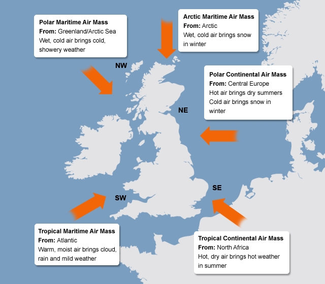
Air masses affecting the British Isles
Weather Fronts
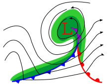
Weather fronts: Formed when two or more air masses with different temperatures and densities don't mix together.
- Warm front: Warm air is forced to override denser, cooler air.
- Cold Front: Cool air is forced to cut under warmer air.
- Occluded front: Mixture of cold and warm fronts. The faster moving cold front overtakes the warm front separating it from the low pressure cyclone centre.
Origin and nature of depressions
Depression = LOW PRESSURE SYSTEM
Depressions occur when two air masses meet, one is a warm, moist mass from the tropics, whilst the other is a cool, dense mass from the Pole.
As a depression moves overhead you can recognise 5 stages in order:
Depressions occur when two air masses meet, one is a warm, moist mass from the tropics, whilst the other is a cool, dense mass from the Pole.
As a depression moves overhead you can recognise 5 stages in order:
- Initially as the depression approaches you will get a build up of high cirrus and stratus clouds. This is because the warm air that has been forced to rise has begun to condensate.
- The cloud will continue to accumulate overhead as the warm front approaches. The clouds will be lower nimbostratus ones and there will be steady rainfall. The temperature will also fall.
- Once the warm front has passed, you are in the section between the two fronts where the warm air still is touching the ground. This causes the temperature to increase, often from approximately 6 to 12C. There may be some light drizzle, but mostly it is dry during this warm sector.
- The next part is the arrival of the cold front. You would be able to see this clearly coming towards you as it is a steep front with huge high cumulonimbus clouds, bringing with them very heavy rain. The temperatures also fall asthe cold front moves overhead.
- Finally, once the cold front has passed, you get a mixture of sunshine and heavy showers, caused by pockets of rising air in the air that follows the depression. The whole process takes between 12 and 24 hours.
|
|
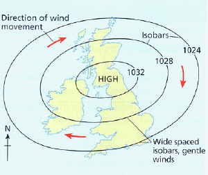
Origin and nature of anticyclones
Anticyclones = HIGH PRESSURE SYSTEM
Summer
Winter
- Only involve one air mass with no weather fronts.
- The presence of high pressure causes air molecules to sink. As the air sinks, it warms, increasing the amount of water the air can hold.
- The descending air warms at the Dry Adiabatic Lapse Rate (DALR- air cools or warms at 9.8ºC for every 1000m ascent or descent through the atmosphere)
- Cloud formation is prevented with low wind speeds due to weak pressure gradients.
Summer
- Clear skies due to descending air brings hot and sunny weather
- Convectional rainfall can occur if the heating of the ground is sufficient. After a few days thunderstorms will signal the end of the anticyclone due to a layer of hot air rising from the surface leading to condensation of water vapour.
Winter
- Clear skies but due to the low position of the sun in the sky, the days are short and fresh.
- Clear skies on a winter's night will allow frost to form. The land quickly loses heat during the night, as there is no cloud cover to act as insulation. The rapidly cooling ground cools and condenses any moisture in the air above it, forming droplets of ice when the temperature falls below freezing. This is frost.
- Fogs are also caused by clear winter nights. The ground loses heat. This cools the air above it causing moisture to condensate around dust particles in the layer of air closest to the ground surface. This is fog.